It has been done! A new data addon for SkyDemon is online!
After some work we can now present you with the glider activity sectors for Germany. If you like the get them for other countries, let me know!

It has been done! A new data addon for SkyDemon is online!
After some work we can now present you with the glider activity sectors for Germany. If you like the get them for other countries, let me know!
SkyDemon Addon to display Glider Activity Sectors within Germany.
All data was sourced from http://www.openaip.net/system/files/airspaces/openaip_airspace_germany_de.aip_1605492096 effective 16NOV2020. (Login required)
To be able to uses the files provided by Discovering Eagle you need to have a
working installation of SkyDemon on Android, iOS or Windows PC and a valid
subscription.
We develop our files with the newest version of SkyDemon at that given time. Even though SkyDemon claims backwards compatibility for custom data, we can’t
guarantee it.
Everything on this website is free! Nevertheless I would appreciate if you donate a little via the support page. I do put a lot of work in these downloads and with every donation you help me coming closer to the ultimate goal: Flying around Africa!
Due to the sandboxing of apss within iOS, at least to our knowledge, it is not
possible to access SkyDemon’s data directory directly on Apple devices. In that
case a workaround might be to follow the PC installation guide and afterwads
sync your PC with you iOS device. More on that below…
CustomData folder matching the nameGermany_Gliding_DDMMMYYYY.airspace in order to prevent previousC:Users< username >Documents/SkyDemon/CustomData. On Android you will find it under < Internal storage >/SkyDemon/CustomData.CustomData folder and make sure not to produce any subfolders!README.md (you can delete this one afterwards)LICENSE.mdGermany_FIS_Fix_DDMMMYYYY.airspaceGermany_FIS_Fix.png (you can delete this one afterwards)Mapping > Airspace > Other. On a mobile device tap the chart layer icon (three panes stacked on top of each other) in the bottom right of the map window and turn on Airspace > Misc.Now you should see multiple airspaces with a dark blue dashed border have appeared. If you utilize the “Whats here” menu you can check the frequency, too.
If you own several devices or at least one iOS device and you’ve followed the
PC installation so far, you can know sync the custom data on all of you devices
origination from your PC. Do to that, select “Setup” from SkyDemon’s top menu
and thereafter select “Custom Data” > “Save to Cloud”. After confirming the
action, know all the custom data will be stored inside SkyDemon’s clound along
with your flightplans and settings.
Now on your mobile device open SkyDemon and go to the “Setup” menu (gear icon)
and select “Cloud” > “Load Custom Data from Cloud”. ATTENTION: All custom data
files that were stored on this device will be overridden with the files from
your PC/cloud!
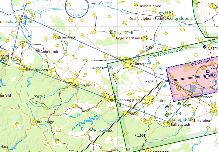
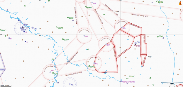
Make sure, Other / Misc airspaces are turned on as described above. Zoom in closer to prevent the sector boundaries been hidden by SkyDemons automatic decluttering feature.
You can check your settings while zooming in to Ballenstedt (EDOI) where there is a glider mountainwave sector north of Harz. See the included screenshot for reference.
If you still do not get any sectors, check if you extracted the archive into your SkyDemon’s CustomData folder without any subfolder. Make sure, you did not change any filename. If you need to correct something here, restart SkyDemon afterwards.
Discovering Eagle did not and does not invent the data provided. See section Data Source above to learn were the provided data came from. We do rework the raw data from our sources and put them into the SkyDemon format.
Unfortunately, it is impossible the verify the correctness of every given dataset. So we must emphasize that the data provided is an aid to flight planning and navigation, designed to enhance situational awareness. The pilot remains responsible for ensuring they have all information necessary for the safe conduct of the flight and that they adhere to the laws of any states overflown. (Did you recognize this paragraph?)
All data provided come with an effective date of the data of the providing entity. Since Discovering Eagle is essentially a one-man-show, I won’t post a cycle end date nor do I guarantee to update my files when the providing entity does. Nevertheless I strive to provide the most up-to-date data possible. Should you find outdated data, please feel free to drop a note on the contact form.
All versions are numbered by their effective date.
16NOV2020 |
Pull from http://www.openaip.net/system/files/airspaces/openaip_airspace_germany_de.aip_1605492096 effective 16NOV2020. |
This project is licensed under an extended MIT License – see the LICENSE.md file for details
Like every year DFS is doing there great spring airspace makeover. During that process the FIS sectors within Germany changed once again and now I do have a new fix for SkyDemon ready to these changes, too. You can download it on Flight Information Service (FIS) Sector Fix for Germany.
Let me know if you like to see these fixes for more European countries!
Extension to show paragliding and hanggliding airfields on the map in SkyDemon. Only includes Germany.
All data was sourced from DHV (Deutscher Gleitschirm- und Drachenflugverband e.V.) effective
21FEB2020.
https://www.dhv.de/piloteninfos/gelaende-luftraum-natur/fluggelaendeflugbetrieb/gelaendedaten/gelaendedaten-download
To be able to uses the files provided by Discovering Eagle you need to have a
working installation of SkyDemon on Android, iOS or Windows PC and a valid
subscription.
We develop our files with the newest version of SkyDemon at that given time. Even though SkyDemon claims backwards compatibility for custom data, we can’t
guarantee it.
All development and testing including creation of the screenshots included in the archive are done with the default “SkyDemon 3” chart style. We do not check nor do we guarantee that the projected features are displayed correctly with the use of other chart styles.
Everything on this website is free! Nevertheless I would appreciate if you donate a little via the support page. I do put a lot of work in these downloads and with every donation you help me coming closer to the ultimate goal: Flying around Africa!
NOTE: At this point, iOS does not allow direct operations on the file system. So the only way to get the data into an Apple device seems to be the import in SkyDemon on a device running either on Android or Windows and then using the SkyDemon cloud to share the data with the Apple device. But be careful, there seems to be a size limit to the SkyDemon cloud!
CustomData folder. On Windows computers you will usually find this at C:Users< username >DocumentsSkyDemonCustomData. On Android you will find it under < Internal storage >/SkyDemon/CustomData.README.md (you can delete this one afterwards)LICENSE.mdparagliding_de_DDMMMYYYY.airspaceparagliding.png (you can delete this one afterwards)Mapping > Airspace > Show Sporting Sites. On a mobile device tap the chart layer icon (three panes stacked on top of each other) in the bottom right of the map window and turn on Airspace > Sporting Activity.Now you should see that multiple dark blue hang-glider symbols have appeared on the map. If you utilize the “Whats here” menu you can check the upper level or contact details, too.
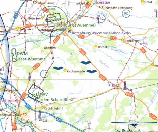
Make sure, Other / Misc airspaces are turned on as described above. Zoom in closer to prevent the sector boundaries been hidden by SkyDemons automatic decluttering feature. You can check your settings while zooming in to Weser-Wuemme (EDWM) and check about 8nm to the east where you should find three paragliding airfields. See the included screenshot for reference.
If you still do not get any airfields, check if you extracted the archive into your SkyDemon’s CustomData folder without any subfolder. Make sure, you did not change any filename. If you need to correct something here, restart SkyDemon afterwards.
Discovering Eagle did not and does not invent the data provided. See section Data Source above to learn were the provided data came from. We do rework the raw data from our sources and put them into the SkyDemon format.
Unfortunately, it is impossible the verify the correctness of every given dataset. So we must emphasize that the data provided is an aid to flight planning and navigation, designed to enhance situational awareness. The pilot remains responsible for ensuring they have all information necessary for the safe conduct of the flight and that they adhere to the laws of any states overflown. (Did you recognize this paragraph?)
All data provided come with an effective date of the data of the providing entity. Since Discovering Eagle is essentially a one-man-show, I won’t post a cycle end date nor do I guarantee to update my files when the providing entity does. Nevertheless I strive to provide the most up-to-date data possible. Should you find outdated data, please feel free to drop a note on the contact form.
All versions are numbered by their effective date.
21FEB2020 |
Pull from https://www.dhv.de/piloteninfos/gelaende-luftraum-natur/fluggelaendeflugbetrieb/gelaendedaten/gelaendedaten-download effective 21FEB2020. |
This project is licensed under an extended MIT License – see the LICENSE.md file for details
Supplements to the already quite good SkyDemon Chart to show various
corrections to the airspace within Germany.
All data is sourced from official aiviation publications. See list of
corrections for further details.
The following corrections were made to SkyDemons default airspace:
| Airport | Sector | Changes | Source | Remarks |
|---|---|---|---|---|
| Hamburg (EDDH) | CTR (HX) Boberg | Sector added | AIP DE IFR ENR 2.1-18 (28MAR2019) | |
| Hamburg (EDDH) | CTR (HX) Finkenwerder | Sector added | AIP DE IFR ENR 2.1-18 (28MAR2019) | |
| Hannover (EDDV) | CTR (HX) Wunstorf | Sector added | ICAO Karte Deutschland 2019 (01APR2019) | |
| Fritzlar (ETHF) | CTR (HX) Mosenberg | Sector added | AIP DE MIL AD2 ETNW-1 (23MAY2019) | |
| Wunstorf (ETNW) | CTR (HX) | Variable area of responsibility added | AIP DE MIL AD2 ETNW-1 (12SEP2009) |
To be able to uses the files provided by Discovering Eagle you need to have a
working installation of SkyDemon on Android, iOS or Windows PC and a valid
subscription.
We develop our files with the newest version of SkyDemon at that given time. Even though SkyDemon claims backwards compatibility for custom data, we can’t
guarantee it.
All development and testing including creation of the screenshots included in
the archive are done with the default SkyDemon 3 chart style. We do not check
nor do we guarantee that the projected features are displayed correctly with
the use of other chart styles.
Everything on this website is free! Nevertheless I would appreciate if you donate a little via the support page. I do put a lot of work in these downloads and with every donation you help me coming closer to the ultimate goal: Flying around Africa!
CustomData folder. On Windows computers you will usually find this at C:Users< username >DocumentsSkyDemonCustomData. On Android you will find it under < Internal storage >/SkyDemon/CustomData.README.md (you can delete this one afterwards)LICENSE.mdGermany_Airspace_Corrections_DDMMMYYYY.airwaysGermany_Airspace_Corrections.png (you can delete this one afterwards)Mapping > Airspace > Show Controlled Airspace A-DMapping > Airspace > Show Controlled Airspace EMapping > Airspace > Show Other AirspaceAirspace > Controlled A-DAirspace > Controlled EAirspace > MiscNow you should see that the airspaces metioned above have appeared.
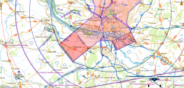
Make sure, all chart layer options are turned on as described above. Zoom in closer to prevent features been hidden by SkyDemons automatic decluttering feature. You can check your settings while zooming in to the area near Hamburg (EDDH). See the included screenshot for reference.
If you still do not get any sectors, check if you extracted the archive into your SkyDemon’s CustomData folder without any subfolder. Make sure, you did not change any filename. If you need to correct something here, restart SkyDemon afterwards.
Discovering Eagle did not and does not invent the data provided. See section Data Source above to learn were the provided data came from. We do rework the raw data from our sources and put them into the SkyDemon format.
Unfortunately, it is impossible the verify the correctness of every given dataset. So we must emphasize that the data provided is an aid to flight planning and navigation, designed to enhance situational awareness. The pilot remains responsible for ensuring they have all information necessary for the safe conduct of the flight and that they adhere to the laws of any states overflown. (Did you recognize this paragraph?)
All data provided come with an effective date of the data of the providing entity. Since Discovering Eagle is essentially a one-man-show, I won’t post a cycle end date nor do I guarantee to update my files when the providing entity does. Nevertheless I strive to provide the most up-to-date data possible. Should you find outdated data, please feel free to drop a note on the contact form.
All versions are numbered by their effective date.
25OCT2019 |
Added the variable area of responsibility for Wunstorf (ETNW). |
15OCT2019 |
Initial compilation from the sources mentioned above. |
This project is licensed under an extended MIT License – see the LICENSE.md file for details
Supplement to SkyDemon’s Germany chart to display missing VFR reporting points and arrival and departure routes as well as traffic patterns for military airports.
Only AD2 aerodromes are included. If you like me to add the AD3 heliports, too, see below how you can get in touch with me.
All data was sourced from Germany’s Military AIP AD2 found for public use at https://www.milais.org/publications.php.
| ICAO | Name | Effective | Remarks |
|---|---|---|---|
| ETAD | Spangdahlem | 23MAY2019 | |
| ETAR | Ramstein | 12SEP2019 | |
| ETHA | Altenstadt | 12SEP2019 | |
| ETHB | Bueckeburg | 12SEP2019 | |
| ETHC | Celle | 12SEP2019 | Pattern CAT B-D included. |
| ETHF | Fritzlar | 23MAY2019 | VFR Reporting Points and Routes for ETHF already included by SkyDemon. Supplemented VRP SE and route to/from EDEM. Downloading Airspace Corrections Germany is recommended to show EDEM sector within ETHF CTR. |
| ETHL | Laupheim | 12SEP2019 | |
| ETHS | Fassberg | 12SEP2019 | |
| ETIC | Grafenwoehr | 23MAY2019 | |
| ETIH | Hohenfels | 23MAY2019 | |
| ETNG | Geilenkirchen | 29MAR2018 | |
| ETNH | Hohn | 12SEP2019 | |
| ETNN | Noervenich | 23MAY2019 | |
| ETNS | Schleswig | 12SEP2019 | |
| ETNT | Wittmundhafen | 12SEP2019 | |
| ETNW | Wunstorf | 12SEP2019 | Downloading Airspace Corrections Germany is recommended to show variable boundary between ETNW and EDDV CTR’s. |
| ETOU | Wiesbaden | 23MAY2019 | |
| ETSB | Buechel | 23MAY2019 | |
| ETSH | Holzdorf | 12SEP2019 | |
| ETSI | Ingolstadt/Manching | 12SEP2019 | Visual Reporting Points and Routes implemented by SkyDemon already. Added holdings north and south of the airfield. |
| ETSL | Lechfeld | 12SEP2019 | |
| ETSN | Neuburg | 12SEP2019 | |
| ETWM | Meppen | 12SEP2019 |
To be able to uses the files provided by Discovering Eagle you need to have a
working installation of SkyDemon on Android, iOS or Windows PC and a valid
subscription.
We develop our files with the newest version of SkyDemon at that given time. Even though SkyDemon claims backwards compatibility for custom data, we can’t
guarantee it.
All development and testing including creation of the screenshots included in
the archive are done with the default SkyDemon 3 chart style. We do not check
nor do we guarantee that the projected features are displayed correctly with
the use of other chart styles.
Everything on this website is free! Nevertheless I would appreciate if you donate a little via the support page. I do put a lot of work in these downloads and with every donation you help me coming closer to the ultimate goal: Flying around Africa!
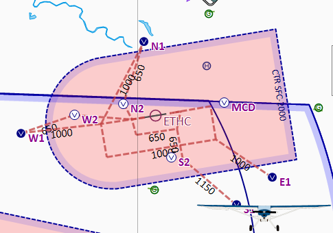
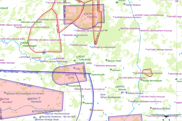
CustomData folder. On Windows computers you will usually find this at C:\Users\< username >\Documents\SkyDemon\CustomData. On Android you will find it under < Internal storage >/SkyDemon/CustomData.README.md (you can delete this one afterwards)LICENSE.mdGEMIL_VFR_DDMMMYYYY.airwaysGEMIL_VFR_DDMMMYYYY.vrps.csvGEMIL_VFR.png (you can delete this one afterwards)Mapping > Waypoints > Show Visual Reporting PointsWaypoints > Visual Reference PointsFor various military airfields in Germany you should see that their respective visual reporting points together with their VFR arrival / departure routes and traffic patterns (brown dashed lines) have appeared. Compare the included screenshot with the Celle Military CTR (ETHC).
Make sure, all chart layer options are turned on as described above. Zoom in closer to prevent features been hidden by SkyDemons automatic decluttering feature. You can check your settings while zooming in to the area near Celle Military (ETHC). See the included screenshot for reference.
If you still do not get any sectors, check if you extracted the archive into your SkyDemon’s CustomData folder without any subfolder. Make sure, you did not change any filename. If you need to correct something here, restart SkyDemon afterwards.
Discovering Eagle did not and does not invent the data provided. See section Data Source above to learn were the provided data came from. We do rework the raw data from our sources and put them into the SkyDemon format.
Unfortunately, it is impossible the verify the correctness of every given dataset. So we must emphasize that the data provided is an aid to flight planning and navigation, designed to enhance situational awareness. The pilot remains responsible for ensuring they have all information necessary for the safe conduct of the flight and that they adhere to the laws of any states overflown. (Did you recognize this paragraph?)
All data provided come with an effective date of the data of the providing entity. Since Discovering Eagle is essentially a one-man-show, I won’t post a cycle end date nor do I guarantee to update my files when the providing entity does. Nevertheless I strive to provide the most up-to-date data possible. Should you find outdated data, please feel free to drop a note on the contact form.
All versions are numbered by their effective date.
12SEP2019 |
Initial compilation from the Military AIP Germany as mentioned above. |
This project is licensed under an extended MIT License – see the LICENSE.md file for details
Adds the waypoints and restricted airspaces for the German Military Night Low Flying System also referred to as ED-R150 to SkyDemon.
All data was sourced from Germany’s Military AIP found for public use at https://www.milais.org/publications.php.
Following pages were referenced and are included in this archive as PDF:
To be able to uses the files provided by Discovering Eagle you need to have a
working installation of SkyDemon on Android, iOS or Windows PC and a valid
subscription.
We develop our files with the newest version of SkyDemon at that given time. Even though SkyDemon claims backwards compatibility for custom data, we can’t
guarantee it.
All development and testing including creation of the screenshots included in
the archive are done with the default SkyDemon 3 chart style. We do not check
nor do we guarantee that the projected features are displayed correctly with
the use of other chart styles.
Everything on this website is free! Nevertheless I would appreciate if you donate a little via the support page. I do put a lot of work in these downloads and with every donation you help me coming closer to the ultimate goal: Flying around Africa!
CustomData folder. On Windows computers you will usually find this at C:\Users\< username >\Documents\SkyDemon\CustomData. On Android you will find it under < Internal storage >/SkyDemon/CustomData.README.md (you can delete this one afterwards)LICENSE.mdED-R150_31JAN2019.airspaceED-R150_31JAN2019.vrps.csvED-R150.png (you can delete this one afterwards)ET_ENR_3_5_1_en.pdf (you can delete this one afterwards)ET_ENR_6_2_en.pdf (you can delete this one afterwards)Mapping > Airspace > Show Prohibited/Restriced AreasMapping > Airspace > Show Night-OnlyMapping > Waypoints > Show Visual Reporting PointsAirspace > Prohibited and RestrictedAirspace > Night-Only AirspaceWaypoints > Visual Reference PointsNow you should see multiple cylindrical airspaces in light red line color connected by slightly smaller corridors have appeared. At the center of each cylinder is a VFR Reporting Point located.
Make sure, all chart layer options are turned on as described above. Zoom in
closer to prevent the sector boundaries been hidden by SkyDemons automatic
decluttering feature. You can check your settings while zooming in to the area
near Hodenhagen (EDVH). See the included screenshot for reference.
If you still do not get any sectors, check if you extracted the archive into your SkyDemon’s CustomData folder without any subfolder. Make sure, you did not change any filename. If you need to correct something here, restart SkyDemon afterwards.
Discovering Eagle did not and does not invent the data provided. See section Data Source above to learn were the provided data came from. We do rework the raw data from our sources and put them into the SkyDemon format.
Unfortunately, it is impossible the verify the correctness of every given dataset. So we must emphasize that the data provided is an aid to flight planning and navigation, designed to enhance situational awareness. The pilot remains responsible for ensuring they have all information necessary for the safe conduct of the flight and that they adhere to the laws of any states overflown. (Did you recognize this paragraph?)
All data provided come with an effective date of the data of the providing entity. Since Discovering Eagle is essentially a one-man-show, I won’t post a cycle end date nor do I guarantee to update my files when the providing entity does. Nevertheless I strive to provide the most up-to-date data possible. Should you find outdated data, please feel free to drop a note on the contact form.
All versions are numbered by their effective date.
31JAN2019 |
Initial compilation from the Military AIP Germany as mentioned above. |
This project is licensed under an extended MIT License – see the LICENSE.md file for details
Fix to show FIS sectors on the map again. Only includes Germany.
All data was sourced from http://www.openaip.net/system/files/airspaces/openaip_airspace_germany_de.aip_1588554066 effective 29APR2020. (Login required)
To be able to uses the files provided by Discovering Eagle you need to have a
working installation of SkyDemon on Android, iOS or Windows PC and a valid
subscription.
We develop our files with the newest version of SkyDemon at that given time. Even though SkyDemon claims backwards compatibility for custom data, we can’t
guarantee it.
Everything on this website is free! Nevertheless I would appreciate if you donate a little via the support page. I do put a lot of work in these downloads and with every donation you help me coming closer to the ultimate goal: Flying around Africa!
CustomData folder matching the nameGermany_FIS_Fix_DDMMMYYYY.airspace in order to prevent previousC:\Users\< username >\Documents\SkyDemon\CustomData. On Android you will find it under < Internal storage >/SkyDemon/CustomData.CustomData folder and make sure not to produce any subfolders!README.md (you can delete this one afterwards)LICENSE.mdGermany_FIS_Fix_DDMMMYYYY.airspaceGermany_FIS_Fix.png (you can delete this one afterwards)Mapping > Airspace > Other. On a mobile device tap the chart layer icon (three panes stacked on top of each other) in the bottom right of the map window and turn on Airspace > Misc.Now you should see multiple airspaces with a dark blue dashed border have appeared. If you utilize the “Whats here” menu you can check the frequency, too.
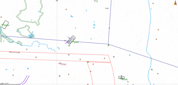
Make sure, Other / Misc airspaces are turned on as described above. Zoom in closer to prevent the sector boundaries been hidden by SkyDemons automatic decluttering feature. You can check your settings while zooming in to Celle-Arloh airfield (EDVC) where the sector boundary should cross west to east right above the airfield and intersect another boundary at Berliner Heide gliderside about 10nm to the east. See the included screenshot for reference.
If you still do not get any sectors, check if you extracted the archive into your SkyDemon’s CustomData folder without any subfolder. Make sure, you did not change any filename. If you need to correct something here, restart SkyDemon afterwards.
Discovering Eagle did not and does not invent the data provided. See section Data Source above to learn were the provided data came from. We do rework the raw data from our sources and put them into the SkyDemon format.
Unfortunately, it is impossible the verify the correctness of every given dataset. So we must emphasize that the data provided is an aid to flight planning and navigation, designed to enhance situational awareness. The pilot remains responsible for ensuring they have all information necessary for the safe conduct of the flight and that they adhere to the laws of any states overflown. (Did you recognize this paragraph?)
All data provided come with an effective date of the data of the providing entity. Since Discovering Eagle is essentially a one-man-show, I won’t post a cycle end date nor do I guarantee to update my files when the providing entity does. Nevertheless I strive to provide the most up-to-date data possible. Should you find outdated data, please feel free to drop a note on the contact form.
All versions are numbered by their effective date.
29APR2020 |
Pull from http://www.openaip.net/system/files/airspaces/openaip_airspace_germany_de.aip_1588554066 effective 29APR2020. |
30SEP2019 |
Pull from http://www.openaip.net/system/files/airspaces/openaip_airspace_germany_de.aip_1570496444 effective 30SEP2019. |
This project is licensed under an extended MIT License – see the LICENSE.md file for details
Turnpoint database for Chilhowee gliderport, Benton, Tennessee, United States
of America (92A).
All data was sourced from http://soaringweb.org/TP/Chilhowee_racing effective
08APR2011.
To be able to uses the files provided by Discovering Eagle you need to have a
working installation of SkyDemon on Android, iOS or Windows PC and a valid
subscription.
We develop our files with the newest version of SkyDemon at that given time.
Even though SkyDemon claims backwards compatibility for cutom data, we can’t
garantee it.
Everything on this website is free! Nevertheless I would appreciate if you donate a little via the support page. I do put a lot of work in these downloads and with every donation you help me coming closer to the ultimate goal: Flying around Africa!
CustomData folder. On Windows computers you will usually find this at C:Users< username >DocumentsSkyDemonCustomData. On Android you will find it under < Internal storage >/SkyDemon/CustomData.README.md (you can delete this one afterwards)LICENSE.mdChilhowee92aGliderTurnpoints_DDMMMYYYY.vrps.csvChilhowee92aGliderTurnpoints.png (you can delete this one afterwards)Mapping > Waypoints > Show Glider Waypoints and navigate to Chilhowee Gliderport (92A).You should see multiple waypoints with a blue dot icon have appeared.
Make sure, Glider Waypoints are turned on as described above. Zoom in closer to
prevent the waypoints been hidden by SkyDemons automatic decluttering feature.
You can check your settings while zooming in to Chilhowee Gliderport (92A) and
compare to the screenshot included in the archive.
If you still do not get any waypoints, check if you extracted the archive into
your SkyDemons CustomData folder without any subfolder. Make sure, you did not
change any filename. If you need to correct something here, restart SkyDemon
afterwarts.
Discovering Eagle did not and does not invent the data provided. See section Data Source above to learn were the provided data came from. We do rework the raw data from our sources and put them into the SkyDemon format.
Unfortunately, it is impossible the verify the correctness of every given dataset. So we must emphasize that the data provided is an aid to flight planning and navigation, designed to enhance situational awareness. The pilot remains responsible for ensuring they have all information necessary for the safe conduct of the flight and that they adhere to the laws of any states overflown. (Did you recognize this paragraph?)
All data provided come with an effective date of the data of the providing entity. Since Discovering Eagle is essentially a one-man-show, I won’t post a cycle end date nor do I guarantee to update my files when the providing entity does. Nevertheless I strive to provide the most up-to-date data possible. Should you find outdated data, please feel free to drop a note on the contact form.
All versions are numbered by their effective date.
08APR2011 |
Initial pull from http://soaringweb.org/TP/Chilhowee_racing effective 08APR2011. |
This project is licensed under an extended MIT License – see the LICENSE.md file for details
Turnpoint database for Celle-Scheuen gliderport, Celle, Lower Saxony, Germany.
All data was sourced from the internal FVC2008.cup file of Flugsportvereinigung Celle Segelfluggruppe e.V. effective before 31DEZ2008.
To be able to use the files provided by Discovering Eagle you need to have a working installation of SkyDemon on Android, iOS or Windows PC and a valid subscription.
I develop my files with the newest version of SkyDemon at that given time. Even though SkyDemon claims backwards compatibility for custom data, I can’t guarantee it.
Everything on this website is free! Nevertheless I would appreciate if you donate a little via the support page. I do put a lot of work in these downloads and with every donation you help me coming closer to the ultimate goal: Flying around Africa!
CustomData folder. On Windows computers you will usually find this at C:\Users\< username >\Documents\SkyDemon\CustomData. On Android you will find it under < Internal storage >/SkyDemon/CustomData.README.md (you can delete this one afterwards)LICENSE.mdCelleScheuenGliderTurnpoints_DDMMMYYYY.vrps.csvCelleScheuenGliderTurnpoints.png (you can delete this one afterwards)Mapping > Waypoints > Show Glider Waypoints and navigate to Celle-Scheuen.You should see multiple waypoints with a blue dot icon have appeared.
Make sure, gilder turnpoints are visible in SkyDemon. Turn them on as described above and zoom in closer than 500k.
Check if you extracted the archive into you SkyDemon’s CustomData folder without any subfolder. Make sure, you did not change any filename.
Discovering Eagle did not and does not invent the data provided. See section Data Source above to learn were the provided data came from. We do rework the raw data from our sources and put them into the SkyDemon format.
Unfortunately, it is impossible the verify the correctness of every given dataset. So we must emphasize that the data provided is an aid to flight planning and navigation, designed to enhance situational awareness. The pilot remains responsible for ensuring they have all information necessary for the safe conduct of the flight and that they adhere to the laws of any states overflown. (Did you recognize this paragraph?)
All data provided come with an effective date of the data of the providing entity. Since Discovering Eagle is essentially a one-man-show, I won’t post a cycle end date nor do I guarantee to update my files when the providing entity does. Nevertheless I strive to provide the most up-to-date data possible. Should you find outdated data, please feel free to drop a note on the contact form.
All versions are numbered by their effective date.
| Initial pull from the internal file FVC2008.cup from Flugsportvereinigung Celle Segelfluggruppe e.V.. |
Changes are noted as followed. See Remarks column for details.
removed added changed
| Latitude | Longitude | Identifier | Name | Remarks |
|---|---|---|---|---|
| N52.656383 | E010.171117 | _GARNO | _GARNO | |
| N52.656383 | E010.171117 | _GARNO | _GARNO | |
| N51.984167 | E009.817833 | ALFELDBF | Alfeld Bahnhof | |
| N52.118050 | E013.950000 | ALTSCHDW | Altschadow | |
| N53.130500 | E010.216667 | AMEX209B | Armelinghausen Kreuzung B209 | |
| N53.017783 | E013.994450 | ANGERMND | Angermuende | |
| N52.880500 | E011.495833 | ARENDSBF | Arendsee Bahnhof | |
| N53.079500 | E010.575000 | BADBEVBF | Badbevensen Bahnhof | |
| N52.707000 | E008.509667 | BARNSTBF | Barnstorf Bahnhof | |
| N52.643050 | E010.269450 | BEEDENYB | Bedenbostel | |
| N52.137500 | E012.597167 | BELZIGBF | Belzig Bahnhof | |
| N52.808333 | E009.983333 | BERGENBH | Bergen Bahnhof | |
| N53.143333 | E010.486333 | BIENENBF | Bienenbüttel Bahnhof | |
| N51.986000 | E008.616667 | BIEXAB68 | Bielefeld Kreuzung B68 | |
| N52.750000 | E011.555550 | BISMARKX | BISMARKX | |
| N53.101667 | E009.978333 | BISPINAA | Bispingen Autobahnabfahrt | |
| N53.294333 | E010.723500 | BLECKEBF | Bleckede Bahnhof | |
| N53.194500 | E009.286167 | BOCKELAA | BOCKELAA | |
| N52.000000 | E010.157167 | BOCKENAA | Bockenem Autobahnabfahrt | |
| N52.833333 | E010.669500 | BODEXSTK | Bad Bodenteich Kreuzung | |
| N52.406167 | E008.034667 | BRAMXA1K | Bramsche Kreuzung Autobahn 1 Kanal | |
| N52.344450 | E012.600000 | BRANDEBA | Brandenburg Autobahnabfahrt | |
| N52.834167 | E010.487500 | BREITENH | Breitenhees | |
| N53.483333 | E009.138883 | BREMERBH | Bremervörde Bahnhof | |
| N52.598667 | E010.929167 | BROX248B | Brome Kreuzung B248 B244 | |
| N53.841667 | E012.006950 | BUETZOEI | Buetzow Eisenbahn | |
| N52.233333 | E011.891667 | BURGAO | Burg Autobahnabfahrt | |
| N53.283617 | E012.975550 | BurgWerg | Burg Wesenberg | |
| N52.158333 | E011.000000 | BUSCHHN | Buschhaus Kraftwerk | |
| N52.811167 | E008.208333 | CLOPPEAA | Cloppenburg Autobahnabfahrt | |
| N51.888833 | E012.400000 | COSWIGAA | Coswig Autobahnabfahrt | |
| N51.484667 | E009.016333 | DIEMELAA | Diemelstadt Autobahnabfahrt | |
| N52.613000 | E008.389167 | DIEX214B | Diepholz Kreuzung B214 B51 | |
| N53.143000 | E011.229167 | DOEMITBR | Doemitz Bruecke | |
| N51.635333 | E012.880000 | DOMMITBF | Dommitzsch Bahnhof | |
| N52.892783 | E009.769450 | DORFMABA | Dorfmark Autobahnabfahrt | |
| N53.337500 | E010.536167 | ECHEM_BF | Echem Bahnhof | |
| N51.794500 | E010.077833 | ECHTE_AA | Echte Autobahnabfahrt | |
| N53.194500 | E010.082833 | EGESTOAA | Egestorf Autobahnabfahrt | |
| N52.194500 | E011.266667 | EILSLEAA | Eilsleben Autobahnabfahrt | |
| N52.216667 | E010.788833 | ELMFTURM | Elm Funkturm | |
| N52.742833 | E010.227833 | ESCHEDBF | Eschede Bahnhof | |
| N52.336000 | E008.609667 | ESPELXBK | Luebbecke Eisenbahnbruecke | |
| N53.159667 | E010.061167 | EVENDOAA | Evendorf Autobahnabfahrt | |
| N52.754500 | E010.050000 | EVERSEN | Eversen | |
| N51.545833 | E013.266667 | FALX183B | Falkenberg Kreuzung B183 | |
| N53.330283 | E013.431383 | FELDBERG | Feldberg | |
| N52.369450 | E010.726383 | FLECHTBA | Flechtdorf Autobahnabfahrt | |
| N51.955833 | E013.767217 | FREIWALD | Freiwalde | |
| N51.455500 | E009.869500 | FRIEDLAA | Friedland Autobahndreieck | |
| N53.188883 | E013.136117 | FUERSTBH | Fuerstenbuerg Bahnhof | |
| N52.516667 | E011.400000 | GARDELBF | Gardelegen Bahnhof | |
| N53.240000 | E010.079500 | GARLSTAA | Garlstorf Autobahnabfahrt | |
| N52.403333 | E012.156383 | GENTHIN | Genthin | |
| N52.495000 | E010.525333 | GIFX4188 | Gifhorn Kreuzung B4 B188 | |
| N52.900000 | E012.083333 | GLOEWEBH | Gloewen Bahnhof | |
| N51.525333 | E009.880333 | GOETTAA | Goettingen Autobahnabfahrt | |
| N53.001950 | E013.166117 | GRANSEE | Gransee | |
| N52.038617 | E014.042217 | GRSSLTHN | Gross Leuthen | |
| N53.772167 | E012.316667 | GUESTRAA | Guestrow Autobahnabfahrt | |
| N53.488833 | E011.279167 | HAGENOAA | Hagenow Autobahnabfahrt | |
| N53.415283 | E011.219450 | HAGENOSU | Hagenow Eisenbahn | |
| N52.295833 | E011.382000 | HALDEXBK | Haldensleben Eisenbahnbruecke | |
| N52.243000 | E011.012500 | HELMSTAA | Helmstedt Autobahnabfahrt | |
| N52.832217 | E010.092500 | HERMANOE | Hermannsburg OHE | |
| N53.072167 | E012.530500 | HERZSPBA | Herzsprung Autobahnabfahrt | |
| N53.140283 | E011.040283 | HITZACBH | Hitzacker Bahnhof | |
| N52.249450 | E011.400283 | HUNDSBRG | Hundisburg | |
| N52.169500 | E011.488833 | IRXLEBAA | Irxleben Autobahnabfahrt | |
| N52.448333 | E010.574667 | ISENBUXB | Isenbuettel Eisenbahnbruecke | |
| N52.953333 | E013.807217 | JCHMSTHL | Joachimsthal | |
| N52.672500 | E009.775283 | JEVERSAL | Jeversen Allerbruecke | |
| N52.662500 | E011.391667 | KALBE BH | Kalbe Bahnhof | |
| N52.631950 | E011.159717 | KLOETZE | Kloetze | |
| N52.314667 | E010.818000 | KOENIGAA | Koenigslutter Autobahnabfahrt | |
| N51.961667 | E012.461950 | KOESELTZ | Koeselitz | |
| N53.680550 | E012.375000 | KRAKOWBA | Krakow Autobahnabfahrt | |
| N52.566667 | E011.033333 | KUNRAUBH | Kunrau Bahnhof | |
| N53.886167 | E012.252833 | LAAGE_AA | Laage Autobahnabfahrt | |
| N52.062500 | E011.950000 | LEITZKSC | Leitzkau | |
| N52.444450 | E011.483333 | LETZJAGD | Letzlingen Jagdschloss | |
| N52.269500 | E007.927833 | LOTTE_XA | Lotte Autobahnkreuz | |
| N52.091950 | E013.161117 | LUCKNWLD | Luckenwalde | |
| N53.422167 | E011.519500 | LUDWIGBA | Ludwigslust Autobahndreieck | |
| N53.336167 | E011.494500 | LUDWIGBF | Ludwigslust Bahnhof | |
| N51.941950 | E013.897217 | LUEBBEN | Luebben | |
| N53.729167 | E011.413883 | LUEBSTBH | Luebstorf Bahnhof | |
| N53.473667 | E012.026333 | LUEBZBF | Luebz Bahnhof | |
| N53.658333 | E011.175000 | LUETZOBH | Luetzow Bahnhof | |
| N53.494333 | E012.384667 | MALCHOAA | Malchow Autobahnabfahrt | |
| N53.225000 | E012.202783 | MEYENBBA | Meyenburg Autobahnabfahrt | |
| N52.483333 | E011.211167 | MIESTEBF | Mieste Bahnhof | |
| N53.266667 | E012.837500 | MIROW X | Mirow Kreuzung | |
| N52.522167 | E010.365333 | MUEDYOKE | Mueden Okermuendung | |
| N53.236117 | E010.891667 | NEU_DAEL | Darchau | |
| N52.902783 | E012.738883 | NEURUPBA | Neu Ruppin Autobahnabfahrt | |
| N53.369450 | E013.075000 | NEUSTRX | Neustrelitz Kreuzung B96 B193 | |
| N52.849167 | E013.941117 | NIEDRFNW | Niederfinow | |
| N52.097217 | E012.691667 | NIEMEGBA | Niemegk Autobahnabfahrt | |
| N52.669167 | E009.180833 | NIENBXWB | Nienburg Weserbruecke | |
| N51.699667 | E009.940833 | NORTH_AW | Northeim Autobahnabfahrt | |
| N52.441667 | E010.983333 | OEBISFBF | Oebisfelde Bahnhof | |
| N53.113883 | E008.272217 | OLDENBOS | Oldenburg Autobahnkreuz | |
| N53.163833 | E010.800000 | OLDXB216 | Oldendorf Kreuzung B216 | |
| N52.475000 | E010.665333 | OSSLOSSX | Ossloss Kreuzung | |
| N53.338833 | E011.800000 | PARCHIAA | Parchim Autobahnabfahrt | |
| N53.299167 | E010.148617 | PATTENDB | Pattensen Eisenbahn | |
| N53.070833 | E011.848333 | PERLEBRG | Perleberg | |
| N53.130500 | E013.883333 | PFINGSAA | Pfingstberg Autobahnabfahrt | |
| N53.461167 | E012.261167 | PLAUBF | Plau Bahnhof | |
| N53.230283 | E013.987783 | PRENZLAU | Prenzlau | |
| N52.966667 | E011.400000 | PREZELLE | Prezelle | |
| N53.363883 | E011.083333 | PRITZIBH | Pritzier Bahnhof | |
| N53.318050 | E010.288883 | RADBRUBH | Radburch Bahnhof | |
| N52.408333 | E011.129167 | RAETZLBH | Raetzlingen Bahnhof | |
| N53.241667 | E008.197217 | RASTEDBH | Rastede Bahnhof | |
| N52.591667 | E012.320833 | RATHENDB | Rathenow Eisenbahn | |
| N53.708333 | E010.775000 | RATZEBDO | Ratzeburg Domsee | |
| N52.787833 | E009.386667 | RETXA209 | Rethen Bruecke B209 | |
| N53.361167 | E012.466667 | ROEBELAA | Roebel Autobahnabfahrt | |
| N52.708333 | E011.041667 | ROHRBXS | Rohrberg Kreuzung B248 | |
| N52.854167 | E011.206833 | SALZWEYB | Salzwedel Eisenbahnabzweigung | |
| N53.294167 | E010.489500 | SCHARNEB | Scharnebeck | |
| N53.167217 | E009.496950 | SCHEESBH | SCHEESBH | |
| N53.066667 | E011.441667 | SCHNACTV | SCHNAC Fernsehturm | |
| N52.016667 | E011.733333 | SCHOENBH | Schoenebeck Bahnhof | |
| N52.675000 | E009.693333 | SCHWARAA | Schwarmstedt Autobahnabfahrt | |
| N52.684717 | E009.598883 | SCHWARLE | Schwarmstedt Bruecke B214 | |
| N53.591667 | E011.500000 | SCHWERAS | Schwerin Autobahnabfahrt | |
| N53.627783 | E011.423617 | SCHWERSC | Schwerin Schloss | |
| N52.890283 | E011.731950 | SEEHAUY | Seehausen Abzweigung B189 B190 | |
| N52.908333 | E010.916667 | SIPTHALX | Spithal Kreuzung | |
| N53.293617 | E009.507783 | SITTENBA | Sittensen Autobahnabfahrt | |
| N51.225500 | E009.610833 | SOEHRETU | Soerewald | |
| N51.638833 | E012.654167 | SOELLIBF | Soellichau Bahnhof | |
| N52.983833 | E009.834167 | SOLTAUBF | Soltau Bahnhof | |
| N53.353883 | E009.418050 | STEDDOTV | Steddort Fernsehturm | |
| N52.658333 | E009.390283 | STEIMBKI | Steimbke | |
| N52.863833 | E009.377500 | STEMMEBF | Stemmn Bahnhofe | |
| N52.594500 | E011.850000 | STENDABF | Stendal Bahnhof | |
| N52.597217 | E012.005550 | STENDAEL | Stendal Eisenbahnbruecke | |
| N52.725000 | E012.008333 | STENDAKR | Stendal Industriegebiet | |
| N53.293000 | E011.983333 | SUCKOWAA | Suckow Autobahnabfahrt | |
| N52.905283 | E010.435550 | SUDERBX | Suderburg Eisenbahn | |
| N52.686167 | E008.815333 | SULINGBF | Sulingen Bahnhof | |
| N52.550000 | E011.986117 | TANGERX | Tangermuende Kreuzung | |
| N52.122217 | E013.646383 | TEUPITZ | Teupitz | |
| N52.233617 | E012.062500 | THEESSEN | Theessen | |
| N51.568000 | E013.009667 | TORGXBEL | Torgau Eisenbahnbruecke | |
| N52.098333 | E012.871117 | TRNBRTZN | Treuenbrietzen | |
| N52.911667 | E010.613050 | UELZENSC | Uelzen Schiffshebewerk | |
| N52.956167 | E009.245500 | VERDENAN | Verden Autobahnabfahrt | |
| N52.602783 | E010.611117 | WAHRENBH | Wahrenholz Bahnhof | |
| N53.402667 | E012.467500 | WALOW937 | Walow Fernsehturm | |
| N52.851833 | E009.556000 | WALSROAW | Walsrode Autobahnabfahrt | |
| N52.777833 | E009.672167 | WESTENAA | Westenholz Autobahnabfahrt | |
| N52.100000 | E012.433333 | WIESENBF | Wiesenburg Bahnhof | |
| N52.113050 | E012.451667 | WIESNBRG | Wiesenburg | |
| N52.566667 | E010.472217 | WILTURM | Wilsche Fernsehturm | |
| N52.677833 | E009.908333 | WINSEABR | Winsen Allerbruecke | |
| N52.736117 | E011.245833 | WINTERX | Winterfeld Kreuzung B71 | |
| N51.866667 | E012.662500 | WITTENBF | Wittenberg Bahnhof | |
| N52.983617 | E011.772217 | WITTENEL | Wittenberge Elbeport | |
| N52.730500 | E010.727667 | WITTINBF | Wittingen Bahnhof | |
| N53.155550 | E012.450000 | WITTSTBA | Wittstock Autobahnabfahrt | |
| N52.307500 | E010.724667 | WOBKOEXA | Wolfsburg Koenigslutter Autobahnkreuz | |
| N53.000667 | E010.838333 | ZARENTXS | Zarenthien | |
| N53.513833 | E010.894500 | ZARRENAA | Zarrentin Autobahnabfahrt | |
| N51.952783 | E012.094450 | ZERBSTBH | Zerbst Bahnhof | |
| N53.069450 | E010.897217 | ZERNIETV | Zernin Fernsehturm | |
| N52.258333 | E012.293333 | ZIESAR | Ziesar | |
| N52.244500 | E012.255500 | ZIESARAA | Ziesar Autobahnabfahrt |
This project is licensed under the MIT License – see the LICENSE.md file for details