Tag Archives: Germany

Gliding_Sector

German Glider Sectors

SkyDemon Addon to display Glider Activity Sectors within Germany.

Data Source

All data was sourced from http://www.openaip.net/system/files/airspaces/openaip_airspace_germany_de.aip_1605492096 effective 16NOV2020. (Login required)

Requirements

To be able to uses the files provided by Discovering Eagle you need to have a
working installation of SkyDemon on Android, iOS or Windows PC and a valid
subscription.

We develop our files with the newest version of SkyDemon at that given time. Even though SkyDemon claims backwards compatibility for custom data, we can’t
guarantee it.

Cost

Everything on this website is free! Nevertheless I would appreciate if you donate a little via the support page. I do put a lot of work in these downloads and with every donation you help me coming closer to the ultimate goal: Flying around Africa!

Installing

Due to the sandboxing of apss within iOS, at least to our knowledge, it is not
possible to access SkyDemon’s data directory directly on Apple devices. In that
case a workaround might be to follow the PC installation guide and afterwads
sync your PC with you iOS device. More on that below…

  1. Remove all files from your SkyDemon’s CustomData folder matching the name
    pattern Germany_Gliding_DDMMMYYYY.airspace in order to prevent previous
    versions to be shown.
    On Windows computers you will usually find this at C:Users< username >Documents/SkyDemon/CustomData. On Android you will find it under < Internal storage >/SkyDemon/CustomData.
  2. Unzip the contents of the downloaded archive to your SkyDemon’s CustomData folder and make sure not to produce any subfolders!
  3. After unzipping you should find the following files:
    • README.md (you can delete this one afterwards)
    • LICENSE.md
    • Germany_FIS_Fix_DDMMMYYYY.airspace
    • Germany_FIS_Fix.png (you can delete this one afterwards)
  4. Now startup SkyDemon. If it has been running close and restart it.
  5. On a Windows PC go to the main menu and turn on Mapping > Airspace > Other. On a mobile device tap the chart layer icon (three panes stacked on top of each other) in the bottom right of the map window and turn on Airspace > Misc.

Now you should see multiple airspaces with a dark blue dashed border have appeared. If you utilize the “Whats here” menu you can check the frequency, too.

If you own several devices or at least one iOS device and you’ve followed the
PC installation so far, you can know sync the custom data on all of you devices
origination from your PC. Do to that, select “Setup” from SkyDemon’s top menu
and thereafter select “Custom Data” > “Save to Cloud”. After confirming the
action, know all the custom data will be stored inside SkyDemon’s clound along
with your flightplans and settings.

Now on your mobile device open SkyDemon and go to the “Setup” menu (gear icon)
and select “Cloud” > “Load Custom Data from Cloud”. ATTENTION: All custom data
files that were stored on this device will be overridden with the files from
your PC/cloud!

It didn’t work

Make sure, Other / Misc airspaces are turned on as described above. Zoom in closer to prevent the sector boundaries been hidden by SkyDemons automatic decluttering feature.

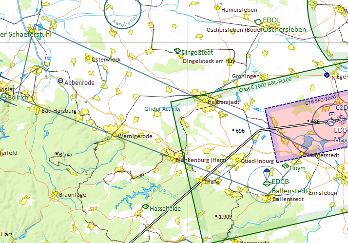
You can check your settings while zooming in to Ballenstedt (EDOI) where there is a glider mountainwave sector north of Harz. See the included screenshot for reference.

If you still do not get any sectors, check if you extracted the archive into your SkyDemon’s CustomData folder without any subfolder. Make sure, you did not change any filename. If you need to correct something here, restart SkyDemon afterwards.

Disclaimer

Discovering Eagle did not and does not invent the data provided. See section Data Source above to learn were the provided data came from. We do rework the raw data from our sources and put them into the SkyDemon format.

Unfortunately, it is impossible the verify the correctness of every given dataset. So we must emphasize that the data provided is an aid to flight planning and navigation, designed to enhance situational awareness. The pilot remains responsible for ensuring they have all information necessary for the safe conduct of the flight and that they adhere to the laws of any states overflown. (Did you recognize this paragraph?)

All data provided come with an effective date of the data of the providing entity. Since Discovering Eagle is essentially a one-man-show, I won’t post a cycle end date nor do I guarantee to update my files when the providing entity does. Nevertheless I strive to provide the most up-to-date data possible. Should you find outdated data, please feel free to drop a note on the contact form.

Versioning/Download

All versions are numbered by their effective date.

download
16NOV2020
Pull from http://www.openaip.net/system/files/airspaces/openaip_airspace_germany_de.aip_1605492096 effective 16NOV2020.

Authors

  • Florian Meissner, founder and front-man of Discovering Eagle.

License

This project is licensed under an extended MIT License – see the LICENSE.md file for details

Contact / Bug-Report

www.discovering-eagle.org/contact

SkyDemon Paragliding Airfield Extension

Paragliding Airfields Extension for Germany

Extension to show paragliding and hanggliding airfields on the map in SkyDemon. Only includes Germany.

Data Source

All data was sourced from DHV (Deutscher Gleitschirm- und Drachenflugverband e.V.) effective
21FEB2020.
https://www.dhv.de/piloteninfos/gelaende-luftraum-natur/fluggelaendeflugbetrieb/gelaendedaten/gelaendedaten-download

Requirements

To be able to uses the files provided by Discovering Eagle you need to have a
working installation of SkyDemon on Android, iOS or Windows PC and a valid
subscription.

We develop our files with the newest version of SkyDemon at that given time. Even though SkyDemon claims backwards compatibility for custom data, we can’t
guarantee it.

All development and testing including creation of the screenshots included in the archive are done with the default “SkyDemon 3” chart style. We do not check nor do we guarantee that the projected features are displayed correctly with the use of other chart styles.

Cost

Everything on this website is free! Nevertheless I would appreciate if you donate a little via the support page. I do put a lot of work in these downloads and with every donation you help me coming closer to the ultimate goal: Flying around Africa!

Installing

NOTE: At this point, iOS does not allow direct operations on the file system. So the only way to get the data into an Apple device seems to be the import in SkyDemon on a device running either on Android or Windows and then using the SkyDemon cloud to share the data with the Apple device. But be careful, there seems to be a size limit to the SkyDemon cloud!

  1. Unzip the contents of the downloaded archive to your SkyDemon’s CustomData folder. On Windows computers you will usually find this at C:Users< username >DocumentsSkyDemonCustomData. On Android you will find it under < Internal storage >/SkyDemon/CustomData.
  2. After unzipping you should find the following files:
    • README.md (you can delete this one afterwards)
    • LICENSE.md
    • paragliding_de_DDMMMYYYY.airspace
    • paragliding.png (you can delete this one afterwards)
  3. Now startup SkyDemon. If it has been running close and restart it.
  4. On a Windows PC go to the main menu and turn on Mapping > Airspace > Show Sporting Sites. On a mobile device tap the chart layer icon (three panes stacked on top of each other) in the bottom right of the map window and turn on Airspace > Sporting Activity.

Now you should see that multiple dark blue hang-glider symbols have appeared on the map. If you utilize the “Whats here” menu you can check the upper level or contact details, too.

It didn’t work

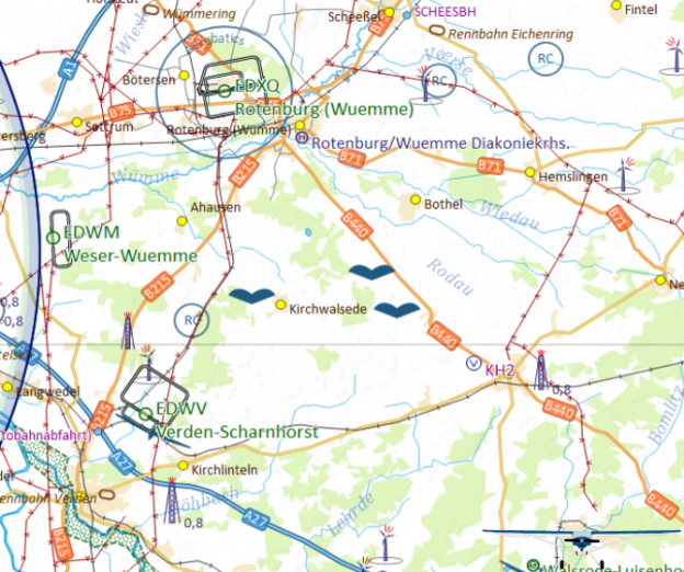
Make sure, Other / Misc airspaces are turned on as described above. Zoom in closer to prevent the sector boundaries been hidden by SkyDemons automatic decluttering feature. You can check your settings while zooming in to Weser-Wuemme (EDWM) and check about 8nm to the east where you should find three paragliding airfields. See the included screenshot for reference.

If you still do not get any airfields, check if you extracted the archive into your SkyDemon’s CustomData folder without any subfolder. Make sure, you did not change any filename. If you need to correct something here, restart SkyDemon afterwards.

Disclaimer

Discovering Eagle did not and does not invent the data provided. See section Data Source above to learn were the provided data came from. We do rework the raw data from our sources and put them into the SkyDemon format.

Unfortunately, it is impossible the verify the correctness of every given dataset. So we must emphasize that the data provided is an aid to flight planning and navigation, designed to enhance situational awareness. The pilot remains responsible for ensuring they have all information necessary for the safe conduct of the flight and that they adhere to the laws of any states overflown. (Did you recognize this paragraph?)

All data provided come with an effective date of the data of the providing entity. Since Discovering Eagle is essentially a one-man-show, I won’t post a cycle end date nor do I guarantee to update my files when the providing entity does. Nevertheless I strive to provide the most up-to-date data possible. Should you find outdated data, please feel free to drop a note on the contact form.

Versioning/Download

All versions are numbered by their effective date.

download
21FEB2020
Pull from https://www.dhv.de/piloteninfos/gelaende-luftraum-natur/fluggelaendeflugbetrieb/gelaendedaten/gelaendedaten-download effective 21FEB2020.

Authors

  • Florian Meissner, founder and front-man of Discovering Eagle.

License

This project is licensed under an extended MIT License – see the LICENSE.md file for details
Contact / Bug-Report

www.discovering-eagle.org/contact

Germany_Airspace_Corrections

Germany Airspace Corrections

Supplements to the already quite good SkyDemon Chart to show various
corrections to the airspace within Germany.

Data Source

All data is sourced from official aiviation publications. See list of
corrections for further details.

List of Airspace Corrections

The following corrections were made to SkyDemons default airspace:

Airport Sector Changes Source Remarks
Hamburg (EDDH) CTR (HX) Boberg Sector added AIP DE IFR ENR 2.1-18 (28MAR2019)
Hamburg (EDDH) CTR (HX) Finkenwerder Sector added AIP DE IFR ENR 2.1-18 (28MAR2019)
Hannover (EDDV) CTR (HX) Wunstorf Sector added ICAO Karte Deutschland 2019 (01APR2019)
Fritzlar (ETHF) CTR (HX) Mosenberg Sector added AIP DE MIL AD2 ETNW-1 (23MAY2019)
Wunstorf (ETNW) CTR (HX) Variable area of responsibility added AIP DE MIL AD2 ETNW-1 (12SEP2009)

Requirements

To be able to uses the files provided by Discovering Eagle you need to have a
working installation of SkyDemon on Android, iOS or Windows PC and a valid
subscription.

We develop our files with the newest version of SkyDemon at that given time. Even though SkyDemon claims backwards compatibility for custom data, we can’t
guarantee it.

All development and testing including creation of the screenshots included in
the archive are done with the default SkyDemon 3 chart style. We do not check
nor do we guarantee that the projected features are displayed correctly with
the use of other chart styles.

Cost

Everything on this website is free! Nevertheless I would appreciate if you donate a little via the support page. I do put a lot of work in these downloads and with every donation you help me coming closer to the ultimate goal: Flying around Africa!

Installing

  1. Unzip the contents of the downloaded archive to your SkyDemon’s CustomData folder. On Windows computers you will usually find this at C:Users< username >DocumentsSkyDemonCustomData. On Android you will find it under < Internal storage >/SkyDemon/CustomData.
  2. After unzipping you should find the following files:
      • README.md (you can delete this one afterwards)
      • LICENSE.md
      • Germany_Airspace_Corrections_DDMMMYYYY.airways
      • Germany_Airspace_Corrections.png (you can delete this one afterwards)
  3. Now startup SkyDemon. If it has been running close and restart it.
  4. Make your map layer settings:
    1. On a Windows PC go to the main menu and turn on the following:
      • Mapping > Airspace > Show Controlled Airspace A-D
      • Mapping > Airspace > Show Controlled Airspace E
      • Mapping > Airspace > Show Other Airspace
    2. On a mobile device tap the chart layer icon (three panes stacked on top of each other) in the bottom right of the map window and turn on this:
      • Airspace > Controlled A-D
      • Airspace > Controlled E
      • Airspace > Misc

Now you should see that the airspaces metioned above have appeared.

It didn’t work

Make sure, all chart layer options are turned on as described above. Zoom in closer to prevent features been hidden by SkyDemons automatic decluttering feature. You can check your settings while zooming in to the area near Hamburg (EDDH). See the included screenshot for reference.

If you still do not get any sectors, check if you extracted the archive into your SkyDemon’s CustomData folder without any subfolder. Make sure, you did not change any filename. If you need to correct something here, restart SkyDemon afterwards.

Disclaimer

Discovering Eagle did not and does not invent the data provided. See section Data Source above to learn were the provided data came from. We do rework the raw data from our sources and put them into the SkyDemon format.

Unfortunately, it is impossible the verify the correctness of every given dataset. So we must emphasize that the data provided is an aid to flight planning and navigation, designed to enhance situational awareness. The pilot remains responsible for ensuring they have all information necessary for the safe conduct of the flight and that they adhere to the laws of any states overflown. (Did you recognize this paragraph?)

All data provided come with an effective date of the data of the providing entity. Since Discovering Eagle is essentially a one-man-show, I won’t post a cycle end date nor do I guarantee to update my files when the providing entity does. Nevertheless I strive to provide the most up-to-date data possible. Should you find outdated data, please feel free to drop a note on the contact form.

Versioning/Download

All versions are numbered by their effective date.

download
25OCT2019
Added the variable area of responsibility for Wunstorf (ETNW).
download
15OCT2019
Initial compilation from the sources mentioned above.

Authors

  • Florian Meissner, founder and front-man of Discovering Eagle.

License

This project is licensed under an extended MIT License – see the LICENSE.md file for details
Contact / Bug-Report

www.discovering-eagle.org/contact

GEMIL_VFR

German Military VFR Reporting Points and Routes

Supplement to SkyDemon’s Germany chart to display missing VFR reporting points and arrival and departure routes as well as traffic patterns for military airports.

Only AD2 aerodromes are included. If you like me to add the AD3 heliports, too, see below how you can get in touch with me.

Data Source

All data was sourced from Germany’s Military AIP AD2 found for public use at https://www.milais.org/publications.php.

Included Airfields

ICAO Name Effective Remarks
ETAD Spangdahlem 23MAY2019
ETAR Ramstein 12SEP2019
ETHA Altenstadt 12SEP2019
ETHB Bueckeburg 12SEP2019
ETHC Celle 12SEP2019 Pattern CAT B-D included.
ETHF Fritzlar 23MAY2019 VFR Reporting Points and Routes for ETHF already included by SkyDemon. Supplemented VRP SE and route to/from EDEM. Downloading Airspace Corrections Germany is recommended to show EDEM sector within ETHF CTR.
ETHL Laupheim 12SEP2019
ETHS Fassberg 12SEP2019
ETIC Grafenwoehr 23MAY2019
ETIH Hohenfels 23MAY2019
ETNG Geilenkirchen 29MAR2018
ETNH Hohn 12SEP2019
ETNN Noervenich 23MAY2019
ETNS Schleswig 12SEP2019
ETNT Wittmundhafen 12SEP2019
ETNW Wunstorf 12SEP2019 Downloading Airspace Corrections Germany is recommended to show variable boundary between ETNW and EDDV CTR’s.
ETOU Wiesbaden 23MAY2019
ETSB Buechel 23MAY2019
ETSH Holzdorf 12SEP2019
ETSI Ingolstadt/Manching 12SEP2019 Visual Reporting Points and Routes implemented by SkyDemon already. Added holdings north and south of the airfield.
ETSL Lechfeld 12SEP2019
ETSN Neuburg 12SEP2019
ETWM Meppen 12SEP2019

Requirements

To be able to uses the files provided by Discovering Eagle you need to have a
working installation of SkyDemon on Android, iOS or Windows PC and a valid
subscription.

We develop our files with the newest version of SkyDemon at that given time. Even though SkyDemon claims backwards compatibility for custom data, we can’t
guarantee it.

All development and testing including creation of the screenshots included in
the archive are done with the default SkyDemon 3 chart style. We do not check
nor do we guarantee that the projected features are displayed correctly with
the use of other chart styles.

Cost

Everything on this website is free! Nevertheless I would appreciate if you donate a little via the support page. I do put a lot of work in these downloads and with every donation you help me coming closer to the ultimate goal: Flying around Africa!

Installing

  1. Unzip the contents of the downloaded archive to your SkyDemon’s CustomData folder. On Windows computers you will usually find this at C:\Users\< username >\Documents\SkyDemon\CustomData. On Android you will find it under < Internal storage >/SkyDemon/CustomData.
  2. After unzipping you should find the following files:
      • README.md (you can delete this one afterwards)
      • LICENSE.md
      • GEMIL_VFR_DDMMMYYYY.airways
      • GEMIL_VFR_DDMMMYYYY.vrps.csv
      • GEMIL_VFR.png (you can delete this one afterwards)
  3. Now startup SkyDemon. If it has been running close and restart it.
  4. Make your map layer settings:
    1. On a Windows PC go to the main menu and turn on the following:
      • Mapping > Waypoints > Show Visual Reporting Points
    2. On a mobile device tap the chart layer icon (three panes stacked on top of each other) in the bottom right of the map window and turn on this:
      • Waypoints > Visual Reference Points

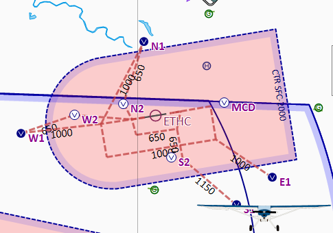
For various military airfields in Germany you should see that their respective visual reporting points together with their VFR arrival / departure routes and  traffic patterns (brown dashed lines) have appeared. Compare the included  screenshot with the Celle Military CTR (ETHC).

It didn’t work

Make sure, all chart layer options are turned on as described above. Zoom in closer to prevent features been hidden by SkyDemons automatic decluttering feature. You can check your settings while zooming in to the area near Celle Military (ETHC). See the included screenshot for reference.

If you still do not get any sectors, check if you extracted the archive into your SkyDemon’s CustomData folder without any subfolder. Make sure, you did not change any filename. If you need to correct something here, restart SkyDemon afterwards.

Disclaimer

Discovering Eagle did not and does not invent the data provided. See section Data Source above to learn were the provided data came from. We do rework the raw data from our sources and put them into the SkyDemon format.

Unfortunately, it is impossible the verify the correctness of every given dataset. So we must emphasize that the data provided is an aid to flight planning and navigation, designed to enhance situational awareness. The pilot remains responsible for ensuring they have all information necessary for the safe conduct of the flight and that they adhere to the laws of any states overflown. (Did you recognize this paragraph?)

All data provided come with an effective date of the data of the providing entity. Since Discovering Eagle is essentially a one-man-show, I won’t post a cycle end date nor do I guarantee to update my files when the providing entity does. Nevertheless I strive to provide the most up-to-date data possible. Should you find outdated data, please feel free to drop a note on the contact form.

Versioning/Download

All versions are numbered by their effective date.

download
12SEP2019
Initial compilation from the Military AIP Germany as mentioned above.

Authors

  • Florian Meissner, founder and front-man of Discovering Eagle.

License

This project is licensed under an extended MIT License – see the LICENSE.md file for details
Contact / Bug-Report

www.discovering-eagle.org/contact

ED-R150

German Military Night Low Flying System (ED-R150)

Adds the waypoints and restricted airspaces for the German Military Night Low Flying System also referred to as ED-R150 to SkyDemon.

Data Source

All data was sourced from Germany’s Military AIP found for public use at https://www.milais.org/publications.php.

Following pages were referenced and are included in this archive as PDF:

  • ENR3.5-1 (31JAN2019)
  • ENR3.5-2 (11OCT2018)
  • ENR3.5-3 (11OCT2018)
  • ENR3.5-4 (13SEP2018)
  • ENR3.5-5 (31MAR2016)
  • ENR3.5-6 (13SEP2018)
  • ENR3.5-7 (13SEP2018)
  • ENR3.5-8 (31MAR2016)
  • ENR3.5-9 (30MAR2017)
  • ENR3.5-10 (13SEP2018)
  • ENR3.5-11 (13SEP2018)
  • ENR3.5-12 (31MAR2016)
  • ENR3.5-13 (26MAY2016)
  • ENR3.5-14 (31MAR2016)
  • ENR3.5-15 (30MAR2017)
  • ENR3.5-16 (26MAY2016)
  • ENR3.5-17 (13SEP2018)
  • ENR6.2 (21JUN2018)

Requirements

To be able to uses the files provided by Discovering Eagle you need to have a
working installation of SkyDemon on Android, iOS or Windows PC and a valid
subscription.

We develop our files with the newest version of SkyDemon at that given time. Even though SkyDemon claims backwards compatibility for custom data, we can’t
guarantee it.

All development and testing including creation of the screenshots included in
the archive are done with the default SkyDemon 3 chart style. We do not check
nor do we guarantee that the projected features are displayed correctly with
the use of other chart styles.

Cost

Everything on this website is free! Nevertheless I would appreciate if you donate a little via the support page. I do put a lot of work in these downloads and with every donation you help me coming closer to the ultimate goal: Flying around Africa!

Installing

  1. Unzip the contents of the downloaded archive to your SkyDemon’s CustomData folder. On Windows computers you will usually find this at C:\Users\< username >\Documents\SkyDemon\CustomData. On Android you will find it under < Internal storage >/SkyDemon/CustomData.
  2. After unzipping you should find the following files:
    • README.md (you can delete this one afterwards)
    • LICENSE.md
    • ED-R150_31JAN2019.airspace
    • ED-R150_31JAN2019.vrps.csv
    • ED-R150.png (you can delete this one afterwards)
    • ET_ENR_3_5_1_en.pdf (you can delete this one afterwards)
    • ET_ENR_6_2_en.pdf (you can delete this one afterwards)
  3. Now startup SkyDemon. If it has been running close and restart it.
  4. Make your map layer settings:
    1. On a Windows PC go to the main menu and turn on the following:
      • Mapping > Airspace > Show Prohibited/Restriced Areas
      • Mapping > Airspace > Show Night-Only
      • Mapping > Waypoints > Show Visual Reporting Points
    2. On a mobile device tap the chart layer icon (three panes stacked on top of each other) in the bottom right of the map window and turn on this:
      • Airspace > Prohibited and Restricted
      • Airspace > Night-Only Airspace
      • Waypoints > Visual Reference Points

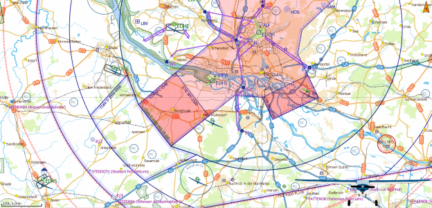
Now you should see multiple cylindrical airspaces in light red line color connected by slightly smaller corridors have appeared. At the center of each cylinder is a VFR Reporting Point located.

It didn’t work

Make sure, all chart layer options are turned on as described above. Zoom in
closer to prevent the sector boundaries been hidden by SkyDemons automatic
decluttering feature. You can check your settings while zooming in to the area
near Hodenhagen (EDVH). See the included screenshot for reference.

If you still do not get any sectors, check if you extracted the archive into your SkyDemon’s CustomData folder without any subfolder. Make sure, you did not change any filename. If you need to correct something here, restart SkyDemon afterwards.

Disclaimer

Discovering Eagle did not and does not invent the data provided. See section Data Source above to learn were the provided data came from. We do rework the raw data from our sources and put them into the SkyDemon format.

Unfortunately, it is impossible the verify the correctness of every given dataset. So we must emphasize that the data provided is an aid to flight planning and navigation, designed to enhance situational awareness. The pilot remains responsible for ensuring they have all information necessary for the safe conduct of the flight and that they adhere to the laws of any states overflown. (Did you recognize this paragraph?)

All data provided come with an effective date of the data of the providing entity. Since Discovering Eagle is essentially a one-man-show, I won’t post a cycle end date nor do I guarantee to update my files when the providing entity does. Nevertheless I strive to provide the most up-to-date data possible. Should you find outdated data, please feel free to drop a note on the contact form.

Versioning/Download

All versions are numbered by their effective date.

download
31JAN2019
Initial compilation from the Military AIP Germany as mentioned above.

Authors

  • Florian Meissner, founder and front-man of Discovering Eagle.

License

This project is licensed under an extended MIT License – see the LICENSE.md file for details
Contact / Bug-Report

www.discovering-eagle.org/contact

Flight Information Service (FIS) Sector Fix for Germany

Fix to show FIS sectors on the map again. Only includes Germany.

Data Source

All data was sourced from http://www.openaip.net/system/files/airspaces/openaip_airspace_germany_de.aip_1588554066 effective 29APR2020. (Login required)

Requirements

To be able to uses the files provided by Discovering Eagle you need to have a
working installation of SkyDemon on Android, iOS or Windows PC and a valid
subscription.

We develop our files with the newest version of SkyDemon at that given time. Even though SkyDemon claims backwards compatibility for custom data, we can’t
guarantee it.

Cost

Everything on this website is free! Nevertheless I would appreciate if you donate a little via the support page. I do put a lot of work in these downloads and with every donation you help me coming closer to the ultimate goal: Flying around Africa!

Installing

  1. Remove all files from your SkyDemon’s CustomData folder matching the name
    pattern Germany_FIS_Fix_DDMMMYYYY.airspace in order to prevent previous
    versions to be shown.
    On Windows computers you will usually find this at C:\Users\< username >\Documents\SkyDemon\CustomData. On Android you will find it under < Internal storage >/SkyDemon/CustomData.
  2. Unzip the contents of the downloaded archive to your SkyDemon’s CustomData folder and make sure not to produce any subfolders!
  3. After unzipping you should find the following files:
    • README.md (you can delete this one afterwards)
    • LICENSE.md
    • Germany_FIS_Fix_DDMMMYYYY.airspace
    • Germany_FIS_Fix.png (you can delete this one afterwards)
  4. Now startup SkyDemon. If it has been running close and restart it.
  5. On a Windows PC go to the main menu and turn on Mapping > Airspace > Other. On a mobile device tap the chart layer icon (three panes stacked on top of each other) in the bottom right of the map window and turn on Airspace > Misc.

Now you should see multiple airspaces with a dark blue dashed border have appeared. If you utilize the “Whats here” menu you can check the frequency, too.

It didn’t work

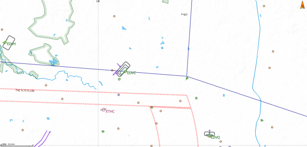
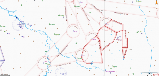
Make sure, Other / Misc airspaces are turned on as described above. Zoom in closer to prevent the sector boundaries been hidden by SkyDemons automatic decluttering feature. You can check your settings while zooming in to Celle-Arloh airfield (EDVC) where the sector boundary should cross west to east right above the airfield and intersect another boundary at Berliner Heide gliderside about 10nm to the east. See the included screenshot for reference.

If you still do not get any sectors, check if you extracted the archive into your SkyDemon’s CustomData folder without any subfolder. Make sure, you did not change any filename. If you need to correct something here, restart SkyDemon afterwards.

Disclaimer

Discovering Eagle did not and does not invent the data provided. See section Data Source above to learn were the provided data came from. We do rework the raw data from our sources and put them into the SkyDemon format.

Unfortunately, it is impossible the verify the correctness of every given dataset. So we must emphasize that the data provided is an aid to flight planning and navigation, designed to enhance situational awareness. The pilot remains responsible for ensuring they have all information necessary for the safe conduct of the flight and that they adhere to the laws of any states overflown. (Did you recognize this paragraph?)

All data provided come with an effective date of the data of the providing entity. Since Discovering Eagle is essentially a one-man-show, I won’t post a cycle end date nor do I guarantee to update my files when the providing entity does. Nevertheless I strive to provide the most up-to-date data possible. Should you find outdated data, please feel free to drop a note on the contact form.

Versioning/Download

All versions are numbered by their effective date.

download
29APR2020
Pull from http://www.openaip.net/system/files/airspaces/openaip_airspace_germany_de.aip_1588554066 effective 29APR2020.
download
30SEP2019
Pull from http://www.openaip.net/system/files/airspaces/openaip_airspace_germany_de.aip_1570496444 effective 30SEP2019.

Authors

  • Florian Meissner, founder and front-man of Discovering Eagle.

License

This project is licensed under an extended MIT License – see the LICENSE.md file for details
Contact / Bug-Report

www.discovering-eagle.org/contact

Countries I’ve been to

Let me share a little list with you where I have been to and how did I get there.

By myself

Germany My home country where I live since I was born.
United States of America I worked and lived there for a year and got my pilots license in the meantime.

Tennessee I lived and worked there for almost one year after my apprenticeship in 2013. During that time I got my pilots license.

Also I returned in 2018 for the summer and flew as a tow pilot at Chilhowee Gliderport (92A) in Benton. Great thanks to Sarah and Jason for giving me my tow pilot endorsement and for let me having fun with their Pawnee!

Kentucky In December 2014 I returned to the States, this time to Kentucky. In Louisville I bought 90B and shipped her home to Celle, Germany.
New York During my year in Tennessee I got the chance to spend a couple of days exploring New York City with my mom.
Georgia Flying in and out of Atlanta, Georgia was and is my gateway to Tennessee.
Alabama During my flight training with Aviation Specialists Inc. at Collegedale Municipal Airport (KFGU), TN I routinely crossed into Alabama and landed at several smaller airfields.
Virginia I drove through these states on my way from Chattanooga, TN to New York City, NY.
Maryland
New Jersey
Illinois I came through these states on the trip to buy 90B when I flew into Chicago, IL and drove down to Louisville, KY.
Indiana
France By myself I’ve been to France just once on my trip to St. Auban and back. But before I’ve been there many times as a child with my family.
United Kingdom After having flown in to the Duxford Flying Legends Airshow as a child with my family, I returned in 90B to explore the country on my own. See British Isles 2019 tour.
Belgium While returning from the British Isles 2019 tour I made a stopover in Brussels to meet Lady Bush Pilot.
Netherlands Just a quick fuel stop on my way to the British Isles. But definitely not the last!
Poland Did at weekend trip to visit the concentration camp memorial in Oswiecim with Tim. See Weekend in Auschwitz

With my family

France Most of our family holidays we spend in the French Alps. We either supported my father to go soaring and went skiing there.
Austria Though we went skiing in France in the very early years of my life, we later moved on to the Austrian Alps.
Italia In 1998 we did a tour around the Alps in our fathers DR400 and did a couple of days layover in northern Italy. I might be back one day…
Denmark First time I came to Denmark, we visited the Legoland in Billund. Later we returned a couple of times to the Baltic Sea Islands.
Sweden It was 2001 when we flew my fathers DR400 up the Lake Vettern in southern Sweden. And I have to admit, the Swedish landscape is one of the most beautiful ones in Europe!
Spain A couple years ago we did another flying adventure. Through France we flew down the Mediterranean coast of Spain until Mallaga where we spend a couple of days.
Morocco From our trip to Spain we took a day trip to Ceuta and Tanger. It was far away from everything I had known from Europe so far! And I was only 12…

Countries / regions I like to go to

Africa Still my ultimate goal is to fly my own plane around Africa one day…
Baltic Sea region I have ideas for flying around the Baltic Sea already…

Canada, Alaska The northern Rocky Mountains in Canada and Alaska are a place I like to go one time.
South America Flying through the Andes mountains like the majestic Condor, soaring over high peaks. I adventure I have to try! But if I do it, I will go down all the way to Ushuaia.
New Zealand New Zealand is so well-known for its beautiful scenery and hospitable people. Do you need more reasons?

Florian