
Adds the waypoints and restricted airspaces for the German Military Night Low Flying System also referred to as ED-R150 to SkyDemon.
Data Source
All data was sourced from Germany’s Military AIP found for public use at https://www.milais.org/publications.php.
Following pages were referenced and are included in this archive as PDF:
- ENR3.5-1 (31JAN2019)
- ENR3.5-2 (11OCT2018)
- ENR3.5-3 (11OCT2018)
- ENR3.5-4 (13SEP2018)
- ENR3.5-5 (31MAR2016)
- ENR3.5-6 (13SEP2018)
- ENR3.5-7 (13SEP2018)
- ENR3.5-8 (31MAR2016)
- ENR3.5-9 (30MAR2017)
- ENR3.5-10 (13SEP2018)
- ENR3.5-11 (13SEP2018)
- ENR3.5-12 (31MAR2016)
- ENR3.5-13 (26MAY2016)
- ENR3.5-14 (31MAR2016)
- ENR3.5-15 (30MAR2017)
- ENR3.5-16 (26MAY2016)
- ENR3.5-17 (13SEP2018)
- ENR6.2 (21JUN2018)
Requirements
To be able to uses the files provided by Discovering Eagle you need to have a
working installation of SkyDemon on Android, iOS or Windows PC and a valid
subscription.
We develop our files with the newest version of SkyDemon at that given time. Even though SkyDemon claims backwards compatibility for custom data, we can’t
guarantee it.
All development and testing including creation of the screenshots included in
the archive are done with the default SkyDemon 3 chart style. We do not check
nor do we guarantee that the projected features are displayed correctly with
the use of other chart styles.
Cost
Everything on this website is free! Nevertheless I would appreciate if you donate a little via the support page. I do put a lot of work in these downloads and with every donation you help me coming closer to the ultimate goal: Flying around Africa!
Installing
- Unzip the contents of the downloaded archive to your SkyDemon’s
CustomDatafolder. On Windows computers you will usually find this atC:\Users\< username >\Documents\SkyDemon\CustomData. On Android you will find it under< Internal storage >/SkyDemon/CustomData. - After unzipping you should find the following files:
README.md(you can delete this one afterwards)LICENSE.mdED-R150_31JAN2019.airspaceED-R150_31JAN2019.vrps.csvED-R150.png(you can delete this one afterwards)ET_ENR_3_5_1_en.pdf(you can delete this one afterwards)ET_ENR_6_2_en.pdf(you can delete this one afterwards)
- Now startup SkyDemon. If it has been running close and restart it.
- Make your map layer settings:
- On a Windows PC go to the main menu and turn on the following:
Mapping>Airspace>Show Prohibited/Restriced AreasMapping>Airspace>Show Night-OnlyMapping>Waypoints>Show Visual Reporting Points
On a mobile device tap the chart layer icon (three panes stacked on top of each other) in the bottom right of the map window and turn on this:Airspace>Prohibited and RestrictedAirspace>Night-Only AirspaceWaypoints>Visual Reference Points
- On a Windows PC go to the main menu and turn on the following:
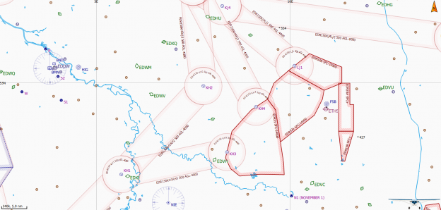
Now you should see multiple cylindrical airspaces in light red line color connected by slightly smaller corridors have appeared. At the center of each cylinder is a VFR Reporting Point located.
It didn’t work
Make sure, all chart layer options are turned on as described above. Zoom in
closer to prevent the sector boundaries been hidden by SkyDemons automatic
decluttering feature. You can check your settings while zooming in to the area
near Hodenhagen (EDVH). See the included screenshot for reference.
If you still do not get any sectors, check if you extracted the archive into your SkyDemon’s CustomData folder without any subfolder. Make sure, you did not change any filename. If you need to correct something here, restart SkyDemon afterwards.
Disclaimer
Discovering Eagle did not and does not invent the data provided. See section Data Source above to learn were the provided data came from. We do rework the raw data from our sources and put them into the SkyDemon format.
Unfortunately, it is impossible the verify the correctness of every given dataset. So we must emphasize that the data provided is an aid to flight planning and navigation, designed to enhance situational awareness. The pilot remains responsible for ensuring they have all information necessary for the safe conduct of the flight and that they adhere to the laws of any states overflown. (Did you recognize this paragraph?)
All data provided come with an effective date of the data of the providing entity. Since Discovering Eagle is essentially a one-man-show, I won’t post a cycle end date nor do I guarantee to update my files when the providing entity does. Nevertheless I strive to provide the most up-to-date data possible. Should you find outdated data, please feel free to drop a note on the contact form.
Versioning/Download
All versions are numbered by their effective date.
31JAN2019 |
Initial compilation from the Military AIP Germany as mentioned above. |
Authors
- Florian Meissner, founder and front-man of Discovering Eagle.
License
This project is licensed under an extended MIT License – see the LICENSE.md file for details